National Weather Service suggests preparing for ‘high-impact winter storm’
By Kathleen Brady Shea, Managing Editor, The Times
 Want a barometer for assessing the severity of this year’s winter weather?
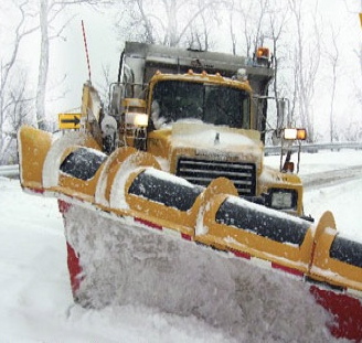
At the direction of Gov. Tom Corbett, the Pennsylvania Department of Transportation (PennDOT) will permit commercial drivers delivering road salt to stay behind the wheel for longer periods of time. PennDOT has extended a waiver put in place last month on certain commercial driving restrictions to facilitate smooth delivery of that scarce and expensive commodity, a PennDOT news release said.
“Though we are entering March, the forecasts call for more winter weather and extending the waiver for drivers of salt trucks will help us overcome the challenges a huge surge in salt demand has placed on the delivery systems,” said PennDOT Secretary Barry J. Schoch. In the meantime, area townships are lamenting the huge deficits the demand has placed on budgets.
The waiver, now in place through March 31, extends the limits on hours of service for salt delivery drivers, who normally must take a mandatory rest period after 11 hours behind the wheel. Under the waiver, the limit for driving hours is extended to 14 hours. An earlier directive was put in place on Feb. 3 and was to expire on Sunday, March 2, which is exactly when the next storm is predicted, the release said.
PennDOT said exemption is also granted from the requirements of the 60/70-hour limits rule, which requires drivers to stop driving upon accumulating 60 or 70 on-duty hours over a period of seven or eight consecutive days, according to the release.
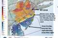
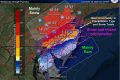
In the meantime, the c is not backing off its prediction of another assault of precipitation. And although the region is still under a warning – which addresses the potential for bad weather – the forecast sounds more ominous: “While there is still uncertainty regarding the amounts of snow, sleet, and freezing rain that will occur Sunday night, there is little doubt that Monday morning will be snowy and cold. This is projecting to be a high impact winter storm…”
The forecast also includes projected snow accumulation of six to 10 inches in the region with a trace of ice. Rain is expected to begin Sunday afternoon and change to freezing rain or sleet before shifting to all snow Sunday night, which will continue until Monday afternoon with temperatures in the 20s and wind gusts up to 25 mph.
As always, emergency officials are urging people to batten down the hatches and stay put. But if you have to venture out, you might want to keep some distance between you and any sleep-deprived, salt-toting truck drivers.